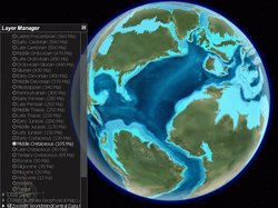
Add-on:Paleomaps
From World Wind Wiki
(Difference between revisions)
| Revision as of 18:55, 27 June 2006 (edit) Withak (Talk | contribs) (changed download url to twobeds) ← Previous diff |
Revision as of 22:29, 5 October 2006 (edit) (undo) Withak (Talk | contribs) (fixed download link) Next diff → |
||
| Line 15: | Line 15: | ||
| ==Links== | ==Links== | ||
| - | *'''Download here''': [http://www.twobeds.com/nasa/withak/paleomaps_1.0.zip Download add-on (60.5 MB)] | + | *'''Download here''': [http://banjopho.be/worldwind/paleomaps_1.0.zip Download add-on (60.5 MB)] |
| *[http://forum.worldwindcentral.com/showthread.php?t=6495 World Wind Forums Thread] | *[http://forum.worldwindcentral.com/showthread.php?t=6495 World Wind Forums Thread] | ||
| *[http://jan.ucc.nau.edu/~rcb7/ Dr. Ron Blakey at the University of Northern Arizona] | *[http://jan.ucc.nau.edu/~rcb7/ Dr. Ron Blakey at the University of Northern Arizona] | ||
Revision as of 22:29, 5 October 2006
| Paleomaps | |
|---|---|
| Paleomaps
| |
| Developer | Withak |
| Latest release | 1.0 / 2006-05-14 |
| License | Undefined |
| Web site | World Wind Forums Thread |
Description
This add-on was made using images developed by Dr. Ron Blakey at the University of Northern Arizona.
The globes presented in this series show how Earth may have appeared over the last 600 million years (Ma). The global views were prepared from rectangular projections drawn at a resolution of 3000x1500 pixels for each of the 26 time slices (small files of the rectangular maps are also included). Topography was "cloned" from digital elevation maps of modern Earth from the USGS. Colors were adjusted to portray climate and vegetation for the given time and location. The modern Earth was also drawn in this manner using a color pallet derived from satellite images created by ARC Science of Loveland, Colorado.


