Add-on:Oceanic Physical Properties Layers
From World Wind Wiki
(Difference between revisions)
| Revision as of 18:47, 23 July 2007 (edit) 69.153.227.159 (Talk) ← Previous diff |
Current revision (17:36, 26 April 2008) (edit) (undo) 70.249.186.94 (Talk) |
||
| Line 16: | Line 16: | ||
| *[http://forum.worldwind.arc.nasa.gov/index.php?showtopic=3841 World Wind Forums Thread] | *[http://forum.worldwind.arc.nasa.gov/index.php?showtopic=3841 World Wind Forums Thread] | ||
| - | *[http://download.worldwindcentral.com/users/bull/Oceanography_Addon_1.1.exe Oceanography_Addon] | + | *[http://www.celestialmuse.org/pangloss/Oceanography_Addon/Oceanography_Addon_1.1.exe Oceanography_Addon] |
| [[Category:Add-ons]] | [[Category:Add-ons]] | ||
Current revision
| Oceanic Physical Properties Layers | |
|---|---|
| Oceanic Physical Properties Layers
| |
| Developer | Pangloss |
| Latest release | ? / July, 2005 |
| License | Free for non-commercial use |
| Web site | PanglossTech Home |
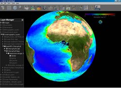
This add-on shows a selection of ocean layers including placenames, bathymetry, temperature, salinity, chlorophyll and a few others. The layers include clickable color scales and links to the agencies/websites where the data originated.
The data include monthly and seasonal maps at ~5 arc-min to 1 degree resolution, depending on the dataset. If anyone knows of higher resolution data, let me know. The placenames were gleaned from a wide range of sources.
There are about 60 maps altogether and the zip file is 173 MB.


